The Best Hikes in the Midwest
The Midwest is certainly not famous for long trails or epic mountain hikes. For example, in my home state of Ohio, the highest point is 1,550-foot Campbell Hill, which can be scaled via sidewalk. However, there are plenty of beautiful hiking options across the Midwest just the same. Here are a few of the best hikes in the Midwest—feel free to add your favorites in the comments.
The Best Hikes in the Midwest
Day Hikes
Hocking Hills State Park, Ohio
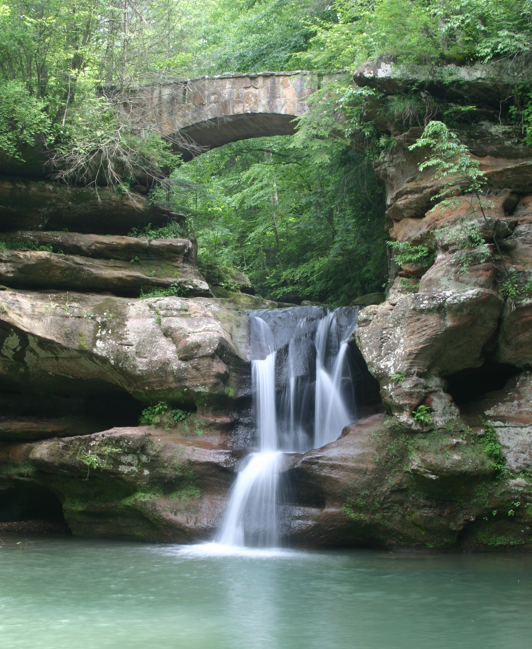
Nestled in southeastern Ohio, Hocking Hills State Park consists of over 2,300 acres of spectacular gorges, waterfalls, and recess caves. Various trails totaling 26 miles allow day hikers to choose an easy or more strenuous trip.
The deep gorges are unlike most of the state and have protected remnant populations of hemlock and Canada yew that flourished there 10,000 years ago during a much cooler time. Camping and cabins are available in the park. The area is extremely popular, so avoiding summer weekend afternoons and other high-use times allow for a more natural experience.
My personal favorite hike is from Old Man's Cave through the gorge to Cedar Falls, then returning on the Gorge Overlook Trail, about six miles total. For those needing more room, the park is adjacent to 9,200 acre Hocking State Forest.
Hocking Hills State Park can be reached from either US Route 33 or Ohio Route 56 southeast of Columbus.
Starved Rock State Park, Illinois
13-Mile Trail Network

Photo courtesy of Illinois Department of Natural Resources.
Canyons, waterfalls, and tall bluffs are not what most people expect when hiking the "flatland" of the Midwest, but that's exactly what day hikers find at 2,600-acre Starved Rock State Park. Thirteen miles of trails wander through 18 canyons and to spectacular overlooks of the Illinois River.
Legend has it that in 1769 a group Ottawa, seeking revenge for the killing of their chief, Pontiac, attacked a group of Illiniwek camping along the Illinois River. In an attempt to escape, the Illiniwek climbed the high butte above the river, but were trapped there by the Ottawa. The standoff continued until the Illiniwek on the butte starved, thus the reason for the park's name. There's now a lodge/restaurant located on a nearby bluff so starvation, or even hunger, is no longer an issue.
Starved Rock is the most popular state park in Illinois, so keep that in mind when picking a time to visit. The views are worth the crowds, though. The park is west of Chicago. Take I-80 W to I-39 S (Exit 79A) to IL 71 E. You'll go right by the entrance.
Indiana Dunes National Lakeshore, Indiana
50-Mile Trail Network
Courtesy of the National Park Service.
Located at the far northwest corner of Indiana along the shore of Lake Michigan, Indiana Dunes National Lakeshore is comprised of 15 separate parcels of land with a total of around 15,000 acres. These individual plots host a wide variety of habitats and an even wider variety of day hike options. Perhaps the hardest part of hiking here is deciding which of the 14 trail systems (totaling 50 miles) to tackle first.
Habitats you can visit include hardwood forests, oak savannas, riparian corridors, prairie, wetland and, of course, dunes and beaches. Between the lake and the variety of environments, the park draws a large variety of birds, despite being in an otherwise urban/industrial area.
Indiana Dunes is located between Gary and Michigan City, IN, with Route 12 passing near most of the parcels.
Overnight and Weekend Hikes
Zaleski State Forest Backpack Trail, Ohio
Ten- to 29-Mile Loops

Looking for a weekend campout that's easy on logistics or perhaps a trail for that first overnight backpacking trip? Well, you have found it at 28,000+ acre Zaleski State Forest. Various loops can be configured to result in hikes of ten, 16, 18, 23 or 29 miles. The terrain is rolling, but not extreme and nearly always in forest. The trail itself is well maintained and (almost) too well marked. I'm still looking for an old photo that showed six blazes at once. A couple overlooks and small recess caves add to the interest.
A permit is required to camp, but they are free and self-issued at the trailhead. There are three camp areas, with each having several separate tent sites. Each camp area includes a latrine and a cistern. (The drinking water is trucked in.)
Zaleski was the site of some of my earliest backpacking and a great place to learn those first lessons. (Such as you don't need six pounds of trail mix for a two-day trip.) The trail is located between Chillicothe and Athens. Take US Route 50 to State Route 278 north.
Charles Deam Wilderness, Indiana
37-Mile Trail Network

Overlooking Lake Monroe.
Encompassing nearly 13,000 acres in south central Indiana, The Deam Wilderness (Indiana's only designated wilderness) is located within Hoosier National Forest and boasts 37 miles of trails. It also touches Lake Monroe, the largest man-made body of water within the state.
The Hickory Ridge Fire Tower, at 110 feet tall, gives some impressive views of the area. Terrill Ridge Trail leads to some excellent campsites near a pond, and the Peninsula Trail provides some striking overlooks of Lake Monroe. At the end of the peninsula are some great lakefront campsites as well.
The wilderness is located south of Bloomington, IN. Take Route 446 to Tower Ridge Road to multiple trailheads. There are no fees or permits required to camp there.
Lakeshore Trail, Pictured Rocks National Lakeshore, Michigan
42 Miles
Photo courtesy of the National Park Service.
Stretching 42 miles along the south shore of Lake Superior, the Lakeshore Trail features incredible overlooks, sandy beaches, waterfalls, lighthouses, and plenty of camping. The distance is also shared with the North Country Trail, which continues a bit further in each direction (approximately 4,600 miles total).
Hiking is moderate with some climbs between bluffs overlooking the lake down to stretches near the water itself. There are 11 backcountry "campgrounds" along the way that can be reserved through recreation.gov. Most camp areas have community fire rings, bear-proof lockers, and water from either streams or that big nearby lake. Bring a water filter. There are shuttle services available for those wanting to hike the entire distance one way.
Pictured Rocks National Lakeshore is located on the south shore of Lake Superior in Michigan's Upper Peninsula, between the communities of Munising (west) and Grand Marais (east). Alger County Road H-58 provides access throughout the Lakeshore.
Longer Backpacking Trails
The Ozark Trail, Missouri
230 Miles

Photo courtesy of the Ozark Trail Association.
A thru-hike of the Ozark Trail is 230 miles, meandering through the St. Francois Mountains of southeast Missouri. Overall, the hiking is moderate with drops into and climbs out of numerous valleys. Elevation changes are generally well under 1,000 feet but enough for some great views. Count on wet stream crossings on a regular basis as well.
Water is not generally an issue, though plan on filtering all sources. Resupply is off trail though several hotels along the route will offer shuttles to those that rent a room. In addition, shuttles are available for the length of the trail so only one vehicle is required.
The northernmost trailhead is reached by heading west from St Louis on I-44 to south on Highway H past Leasburg.
The Superior Trail, Minnesota
255 Miles
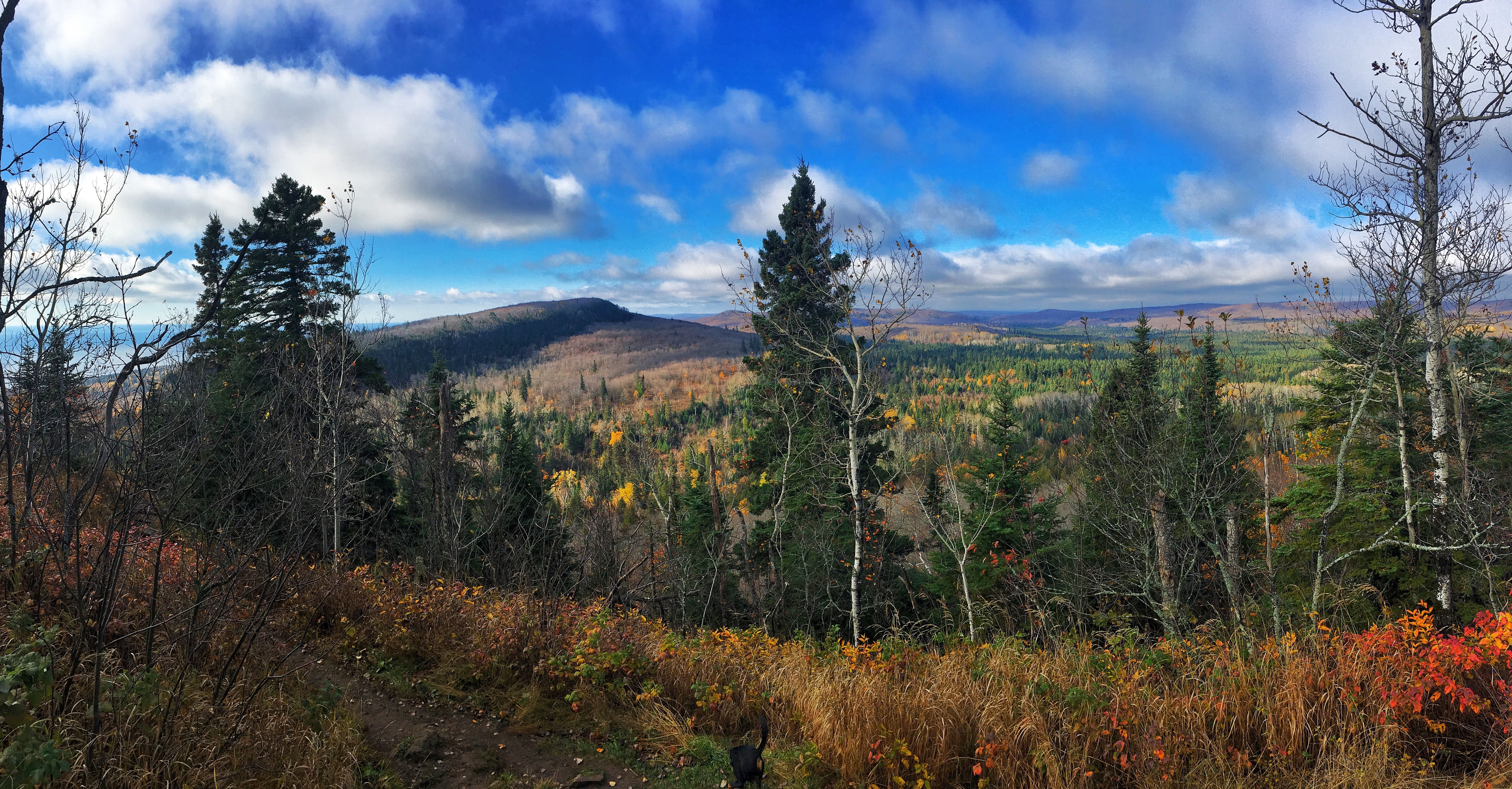
Photo courtesy of the Superior Hiking Trail Association.
The Superior Hiking Trail runs 255 miles, generally along a ridge above the north shore of Lake Superior. The linear route travels nearly to the Canadian border from Duluth. The trail actually continues 41 additional miles south through the city toward the Wisconsin border. However, as no backcountry camping is allowed through this stretch, it is not considered to be part of a traditional thru-hike.
Not surprisingly, the main highlight of the trail is the nearby presence of the big lake the Ojibwa people (and Gordon Lightfoot) called Gitchi Gami (Big Water). Stunning views of the water are common. Numerous streams and rivers flow into the lake and the path is often situated to provide a view of a spectacular waterfall as the flow drops off the ridge down to the lake.
The trail itself doesn't have huge climbs. The lake sits at around 600 feet above sea level and the high point on the trail is a bit over 1,200 feet higher. Consider the trail to be moderate to challenging though. Hiking is rarely on flat ground, with steep elevation changes between river valleys and ridgetop.
There are no permits or fees to hike the trail. Campers are required to stay at one of 93 established backcountry campsites. Each site offers multiple tent pads, a fire ring, and a latrine. Typically, a water source is nearby.
The southern terminus for a traditional thru-hike is the Martin Road trailhead. From I-35, take 21st Ave. East Exit #258. Turn left on 21st Ave. E. and go 0.7 miles up hill. Turn right on Woodland Ave. and go 1.2 miles. Turn right on Snively Rd. and go 1.0 miles to intersection with Jean Duluth Rd. Continue straight on Jean Duluth Rd. and go 1.9 miles. Turn left on Martin Rd. and go 1.2 miles to trailhead parking lot on left. Two shuttle companies are in the area for those wanting a one-way hike.
The Buckeye Trail, Ohio
1,440 Miles

Despite long portions being road walks or paved trail, there is still nature to be seen,
The Buckeye Trail is an interesting animal. I put it in this best hikes in the Midwest list due to its sheer length while staying within one state. It wanders 1,444 miles all over the state of Ohio in a big loop that also has a couple of smaller loops and spurs included. In one spot or another, the trail shares tread with most of the trails in the state I've ever hiked. If you want to thru-hike a trail that few others have completed, this could be your trail. If you want a thru-hike that includes hundreds of miles of road walks and significant stretches with no camping options, this could also be your trail.
There are a lot of good options for section hikes, however. The pathway travels through Ohio's only national forest, Cuyahoga Valley National Park, 18 state parks, five state forests, four wildlife areas, eight Ohio Historical Society properties, six Watershed Conservancy lands and 18 county or Metropark lands. Whatever length and challenge level of a hike you are looking for, chances are you can find it on the Buckeye Trail.
Discover More